Indexes:
About this entry:
- Updated 4 September 2010
- Updates planned: 1
|
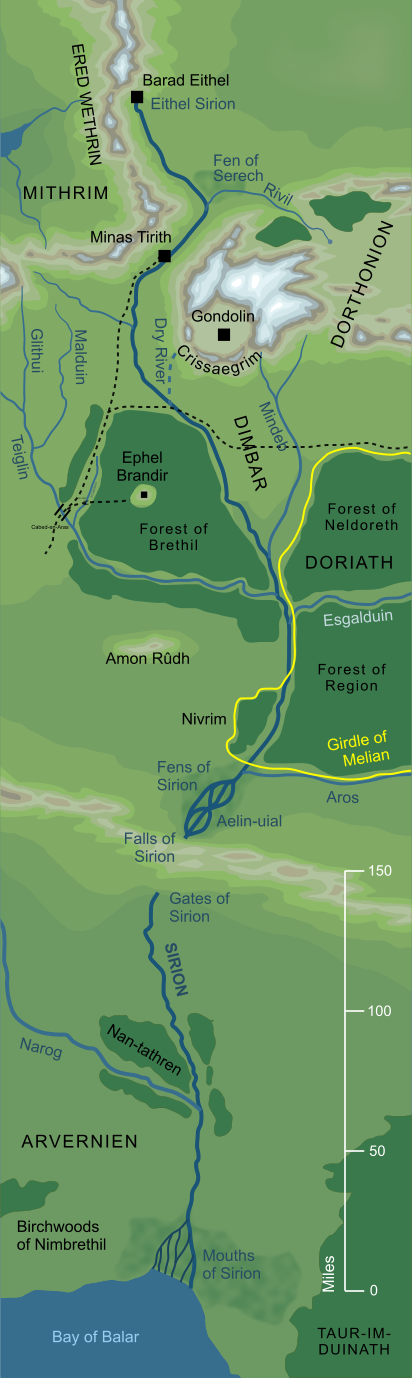
River Sirion
The great river of Beleriand
The greatest of the rivers of Beleriand, the Sirion flowed some 850 miles from its source in the cold highlands of Ered Wethrin to its mighty delta on the Bay of Balar. It was unusual in that, for some nine miles of its middle course, it flowed underground from the wide, enchanted marshland of Aelin-uial beneath the high land known as the Andram. The Sirion was regarded as the border between East and West Beleriand.
See also...
Aelin-uial, Bar-en-Nibin-noeg, Barad Eithel, Bay of Balar, Brithiach, Butterflies, Dimbar, Doriath, Dry River, Eärendil, East Beleriand, Eithel Sirion, Eldar of Hithlum, Elves of Sirion, Exiles of Gondolin, [See the full list...]Falathrim, Falls of Sirion, Fell Winter of the First Age, Fen of Serech, Fens of Sirion, Ford of Brithiach, Forest between the Rivers, Gates of Sirion, Gaurwaith, Havens of Sirion, Lisgardh, Long Wall, Magor, Meres of Twilight, Methed-en-glad, Moors of the Nibin-noeg, Mouths of Sirion, Nan-tasarion, Nan-tathren, Narrow Land, Nibin-noeg, Nivrim, Noegyth Nibin, Pass of Sirion, Ramdal, Ravines of Teiglin, Reeds, River Aros, River Esgalduin, River Glithui, River Mindeb, River Narog, River Rivil, River Teiglin, Rivil’s Well, Rushock Bog, Sauron’s Isle, Seven Gates of Gondolin, Sirion’s Vale, Sources of Narog, Tasarinan, The Highway, Three Jewels, Tol Sirion, Tol-in-Gaurhoth, Twilight Meres, Vale of Narog, Vales of Sirion, West Beleriand, West March
Indexes:
About this entry:
- Updated 4 September 2010
- Updates planned: 1
For acknowledgements and references, see the Disclaimer & Bibliography page.
Original content © copyright Mark Fisher 1998, 2001, 2010. All rights reserved. For conditions of reuse, see the Site FAQ.
|