The Encyclopedia of Arda - an interactive guide to the world of J.R.R. Tolkien

Indexes:

About this entry:

  • Updated 11 July 2026
  • Updates planned: 1

Folde

A region of the King’s Lands of Rohan

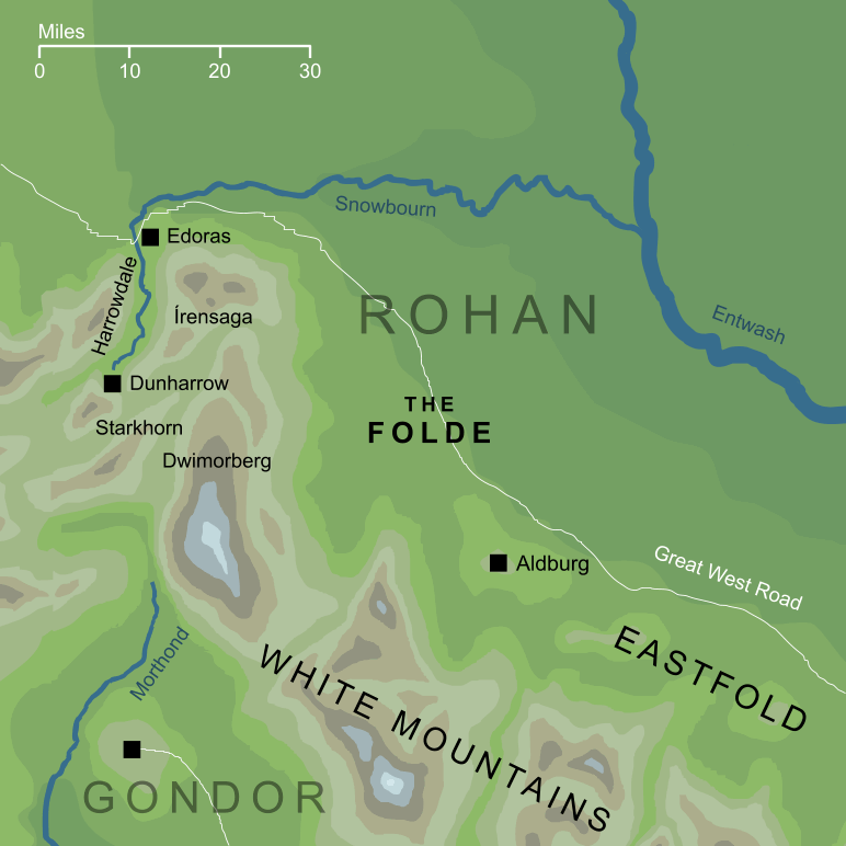
Map of the Folde
The Folde of Rohan (slightly conjectural)1

The more populated regions of Rohan were the valleys and plains that ran along the feet of the White Mountains. These were divided into the three regions: the Westfold, the Eastfold and - centrally and most historically important - the Folde. All three of these took their names from the Old English folde, meaning 'land' or 'country'.

The Folde was a region some sixty or seventy miles across, bounded to the west and south by the heights of the White Mountains, and to the north by the river Snowbourn. To the east it had no natural boundaries to mark its transition into the Eastfold.3 In the southeast, a hill below the mountains was the site of Eorl's original seat, Aldburg, while in the northeast was the later capital and seat of Kings, Edoras.

Edoras was the administrative and military centre not only of the Folde itself, but also of the Eastfold, which had no large towns or fortifications of its own. Though the Kings had dwelt in Edoras after the raising of the Golden Hall there by Brego, Aldburg remained important, and was held by descendants of Brego's son Eofor. At the time of the War of the Ring, Aldburg was home to Éomer, who was a distant descendant of Eofor and one the three Marshals of the Mark.

The Great Road that joined Rohan to Gondor passed southeastward through the Folde. From Edoras in the northwest, the road ran to Aldburg and then onward, crossing into the Eastfold and then towards Fenmarch and the Mering Stream that marked Gondor's formal border with Rohan. It was along this road through the Folde that Théoden led his mustered Riders towards the defence of Minas Tirith in the War of the Ring.


Notes

1

The geography of the map shown here is almost entirely established in canon, with the sole exception of the town of Aldburg. We know that it was within the Folde, and that it stood on a hill, so it must have been close to the point marked on the map, but its precise location is not known with certainty.

2

The notional border between the Folde and Eastfold was said to have been formed by a line running approximately southwestward from the junction of the rivers Snowbourn and Entwash. The word 'approximately' is important here, because a direct southwestward line would have cut Aldburg from the Folde (whereas we're specifically told that it belonged within the region). So, the actual border must have run in a direction closer to south-southwestward than this suggests (or to have been irregular enough to encompass Aldburg within the Folde's southeastern boundaries).

Indexes:

About this entry:

  • Updated 11 July 2026
  • Updates planned: 1

For acknowledgements and references, see the Disclaimer & Bibliography page.

Original content © copyright Mark Fisher 1997-2026. All rights reserved. For conditions of reuse, see the Site FAQ.

Website services kindly sponsored by Axiom Discovery aptitude and skill testing.
Personality is one part of understanding a candidate's suitability, but aptitudes and skills are also key.
The Encyclopedia of Arda
Menu
Homepage Search Latest Entries and Updates Random Entry