The Encyclopedia of Arda - an interactive guide to the world of J.R.R. Tolkien
Dates
Constructed sometime after the foundation of Gondor in II 33201
Location
Running from South Ithilien across the river Poros, and then through Harondor (South Gondor) and across the river Harnen into the Harad itself
Race
Division
Culture
Settlements
The Crossings of Poros at the road's northern end were reached by roads running southward from both Pelargir and Minas Ithil (later Minas Morgul)
Pronunciation
Harad is pronounced 'ha'rad'
Meaning
Harad means 'South' or 'southern lands'

Indexes:

About this entry:

  • Updated 18 May 2026
  • This entry is complete

Harad Road

The road that ran south out of Ithilien

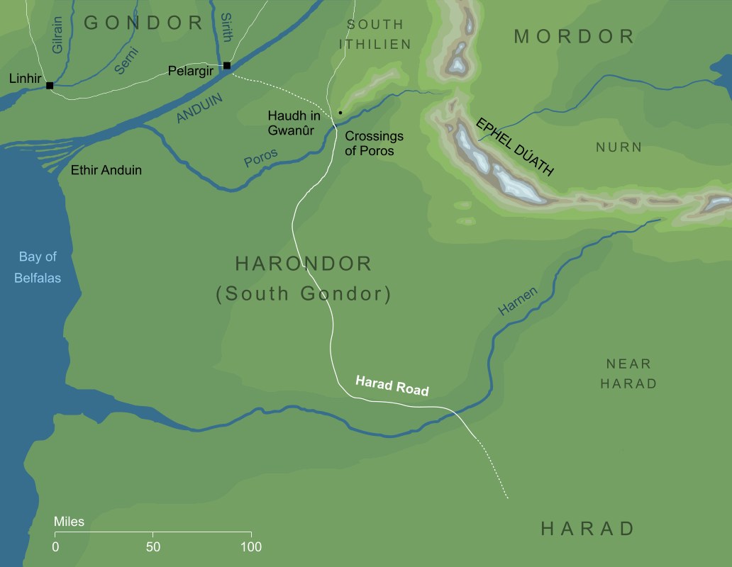
Map of the Harad Road
The route of the Harad Road2

A long road that ran from the southern borders of Gondor on into the distant southern lands of the Harad. Its northern end was on the river Poros, where the roads from Pelargir and Ithilien joined at the river's fords at the southern frontier of Gondor proper. From there it ran southwards for some two hundred miles across the land of Harondor or South Gondor, before crossing the river Harnen and continuing on into the Harad itself.

The origins and history of the Harad Road are almost entirely unknown. The northern stretch that ran through Harondor would have been under Gondorian control through the first half of the Third Age, and thus it could have been constructed and maintained during that period. Beyond Harnen, however, the road ran into lands that were not only outside Gondor's sway for most of its history, but were held by its traditional foes, the Haradrim.

In the year III 1050 King Ciryaher Hyarmendacil of Gondor defeated the Haradrim in battle, and over the following several centuries Harad became a tributary nation to the Gondorians. If there was a period in history when the road was most likely established, it would be this one, which lasted until the loss of Umbar in III 1448. The power of Gondor was thus diminished over both the Harad and South Gondor, and thus the realm also effectively lost control over the Harad Road.

After this the road would have been little travelled, and presumably would have begun to fall into decay. Nonetheless, it was still usable when it was mentioned in annals in III 1944, when the Haradrim used it to cross Poros into Ithilien and attempt an unsuccessful invasion of Gondor. The river crossing, at least, was still in use centuries later (the Haradrim attempted another invasion there as late as III 2885). The course of the road still appears on maps of the region dating from the end of the Third Age,3 so at least some trace of it must have remained even at that point.


Notes

1

We have very few references to the Harad Road of any kind, and none to provide definite dates. Indeed, the road may have existed in some form, perhaps as a trading route, before the foundation of Gondor. Its most likely date of construction, however, would probably be about the year III 1050, when Ciryaher (later Hyarmendacil I) of Gondor marched a great army southward to the relief of Umbar. He is noted as taking several decades to prepare for this action, and the need to build a road for his troops through Harondor (South Gondor) would help to explain this delay. Whenever the road was made, it was probably in existence by III 1448, because Harondor was lost to Gondor in that year. Our first reference to the road comes long after all of these dates, during the battles of III 1944, though even here the records merely imply its existence (speaking of a road across the Fords of Poros) rather than naming it outright.

2

The route of the road southward from the Crossings of Poros is well established, at least until it passed beyond Harnen into the Harad itself. The status of its northern section (through South Ithilien, between Pelargir and the Crossings of Poros) is less clear. It was evidently a continuation of the same road, but this northern section is not definitively identified as part of the main Harad Road.

3

The maps in later editions of The Lord of the Rings show the Harad Road crossing Harnen and then continuing for some fifty miles onward into the Harad before fading away. Maps from earlier editions give a much longer route, showing the road extending far southeastwards, deep into the heart of the Harad (or Haradwaith as the region is labelled there, with an arrow indicating that it continued even farther than this).

Indexes:

About this entry:

  • Updated 18 May 2026
  • This entry is complete

For acknowledgements and references, see the Disclaimer & Bibliography page.

Original content © copyright Mark Fisher 1997-2026. All rights reserved. For conditions of reuse, see the Site FAQ.

Website services kindly sponsored by myDISCprofile, the free online personality test.
How do your personal strengths fit in with career matching? How can you identify them? Try a free personality test from myDISCprofile.
The Encyclopedia of Arda
Menu
Homepage Search Latest Entries and Updates Random Entry