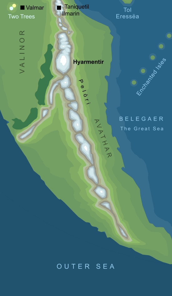
Approximate location of Hyarmentir (conjectural)2
Standing to the south of Valinor in the Blessed Realm to the west of the Great Sea, Hyarmentir was said to have been the tallest mountain in its part of the world. It seems to have formed part of the Mountain Wall of the Pelóri that were raised to protect the land of the Valar.3 Its outer face was a perilous cliff composed of clefts and pinnacles, while the side of the mountain that looked northward towards Valinor had gentler slopes running down toward the forests of Oromë at its feet. From its high peak the wide fields of Valinor could be seen, as well as the Two Trees with the city of Valmar shining beneath.
The precipitous Mountain Wall had been raised long beforehand to protect Valinor against Melkor, but ironically Melkor was able to find a way to scale the heights. After his escape out of Valinor, he allied himself with a monstrous spider-like being, Ungoliant. The monstrous spider was able to climb the face of Hyarmentir, and then let down a woven ladder so that Melkor could follow her to the mountain's peak. From there the pair descended into Valinor itself, where they destroyed the Two Trees and escaped from Aman in an impenetrable cloud of darkness.
Notes
1 |
The interpretation of the name Hyarmentir as 'southern watch' seems clear, though it is difficult to fully parse its meaning. The reason behind 'southern' or 'south' in its name is obvious, as it lay to the south of Valinor, but 'watch' is more problematic. The tir element usually implies a watch-tower or guard post, but in this case the Silmarillion goes out of its way to point out that the Valar did not maintain any watch in this area. Morgoth and Ungoliant stood on the summit of this mountain and looked out over Valinor before they attacked the Two Trees, and so perhaps it only subsequently acquired the name Hyarmentir in recollection of this event.
|
2 |
The geography shown on this map comes from a sketch map identified as 'Map V' in volume IV of The History of Middle-earth. This is a rough map from early in the development of Tolkien's work, but it does at least give us an impression of the arrangement of mountain ranges in this part of the world. Unfortunately, Hyarmentir is not specifically marked on that map, so identifying its exact location is problematic.
Our only clues come from the text of The Silmarillion, which states that it lay far to the south of Taniquetil, and that, from its summit, the city of Valmar lay northward, while the woods of Oromë and the fields beyond lay to the west. When Melkor set out from its peak into Valinor he '...leapt swiftly down the long western slopes' (Quenta Silmarillion 8, Of the Darkening of Valinor). In combination, these references imply that Hyarmentir must have stood at a point eastward of the most southerly parts of Valinor.
|
3 |
Hyarmentir is not specifically said to have been part of the Pelóri, but the description of the mountain, with its sheer outer face, seems to match the precipitous defences of the mountains of that range.
|
Indexes:
About this entry:
- Updated 3 May 2026
- This entry is complete
For acknowledgements and references, see the Disclaimer & Bibliography page.
Original content © copyright Mark Fisher 2005, 2021-2022, 2026. All rights reserved. For conditions of reuse, see the Site FAQ.